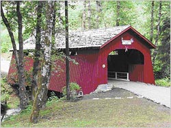
In the early 1900's there were over 400 covered bridges in Oregon. Today, a little over
50 remain, most of which are located in the Willamette Valley. We've put together a covered
bridge loop that will lead you through the beautiful Oregon mountains and across crystal streams,
leading you through 10 of these bridges and two majestic dams. When you stop and enjoy the
scenery and history that is uniquely Oregon, this ride should take most of the day, but well
worth it! For more information on the bridges included in this ride, please visit the
Covered Bridges Web site.
Covered Bridges Loop
Begin at intersection of I-5 & Hwy 20 at Albany
Loop Riding Distance: 209 miles
|

|
-
Hoffman Bridge: Near Albany, take Hwy. 20 east off I-5 (Exit 233).
Ride 5.5 mi. and turn left onto Hwy. 226. Ride 2.4 mi. and turn left
onto Cold Springs Rd. Turn right on Crabtree Dr. and take the next
left onto Hungry Hill Rd., which will take you to Hoffman Bridge
which crosses Crabtree Creek.

-
Gilkey Bridge:
After you cross Hoffman Bridge, continue east on Hungry Hill Rd. and turn left
onto Hwy. 226. Ride 2.5 mi. and turn left onto Gilkey Rd. Ride 3.25 mi. and
turn right onto Goar Rd., which will take you to Gilkey Bridge which crosses
Thomas Creek.

-
Shimanek Bridge:
After you cross Gilkey Bridge, continue north on Goar Rd. and turn right onto Robinson Dr.
Ride 2.7 mi. and turn right onto Main St. in downtown Scio, then take the next left onto
Hwy. 226. Ride 2.2 miles and turn left onto Richardson Gap Rd., which will take you
to Shimanek Bridge.

-
Hannah Bridge:
After crossing Shimanek Bridge, take the first right onto Shimanek Bridge Dr.
Continue east on Shimanek Bridge Dr. and turn left onto Hwy. 226 eastbound.
Ride 2.25 mi. and turn right onto Camp Morrison Dr., which will take you to Hannah
Bridge which crosses Thomas Creek.

-
Larwood Bridge:
Turn around and return to Hwy. 226. Turn left onto Hwy. 226 and remain on Hwy.
226 until you reach Richardson Gap Rd. Turn left onto Richardson Gap Rd. and
ride 2.8 miles to Larwood Dr. Turn left onto Larwood Dr. and ride about 4.5
miles to Larwood Bridge. After crossing Larwood Bridge, stay on Fish Hatchery
Dr. and ride 6.7 mi. (crossing Richardson Gap Rd.), and turn left on Hwy. 226.
Ride 4.3 mi. and turn left onto Hwy. 20.

- Corps Dams Side Trip!
Since you're in the area, a nice side trip is to see the Foster and Green Peter Dams,
owned and operated by the U.S. Army Corps of Engineers. Ride approx. 20 mi. southbound
on Hwy. 20 (Santiam Hwy.), and just before entering Sweet Home, turn left onto Pleasant
Valley Rd. Cross over the Santiam River and turn right onto N. River Dr. Ride 4.4 mi.
to Foster Dam, and another 7.0 mi. to Green Peter Dam. (Just past Foster Dam, N. River
Dr. will turn into Quartzville Rd.) Turn around at Green Peter Dam and retrace your
route back to the Santiam Hwy. Turn left onto Hwy 20 and ride 0.3 mi. to Sweet Home.
For those worried about gas, the Corps dam side trip will add about 24 miles to your
odometer before you gas up in Sweet Home!

Recommended Gas Stop at Sweet Home! (Approx. mileage: 97 mi.)
-
Weddle Bridge:
Before leaving Sweet Home, there's a covered bridge in town! Find Long St. and follow it
to 13th St. Turn right onto 13th St., left onto Kalmia St., and right onto 14th St.,
which will take you to Weddle Bridge which crosses Ames Creek at Stanley Park. After
crossing Weddle Bridge, return to downtown Sweet Home and Hwy. 20.

-
Short Bridge:
In Sweet Home, turn right onto the Hwy. 20, and head east for 14 mi. towards Cascadia.
Turn left onto High Deck Rd. (Cascadia Dr.) which takes you across Short Bridge which
crosses the South Santiam River. After enjoying this bridge, turn around and retrace
your route back to Sweet Home.

-
Crawfordsville Bridge:
In Sweet Home, turn right onto the Hwy. 20, and head east for 14 mi. towards Cascadia.
Turn left onto High Deck Rd. (Cascadia Dr.) which takes you across Short Bridge which
crosses the South Santiam River. After enjoying this bridge, turn around and retrace
your route back to Sweet Home.

-
Earnest Bridge:
Turn right onto Brush Creek Rd. and head southbound for 13.3 mi. to Paschelke Rd.
During your southbound ride, Brush Creek Rd. will turn into Marcola Rd. at the Lane
County line. Turn left onto Paschelke Rd. which takes you across Earnest Bridge
which crosses the Mohawk River.
-
Wendling Bridge:
After crossing Earnest Bridge, continue southbound on Paschelke Rd. for 1.3 mi. to
Wendling Rd. Turn left onto Wendling Rd. and ride 2.0 miles to Wendling Bridge, which
crosses Mill Creek.

Close the Loop! After crossing Wendling Bridge, turn around and follow Wendling Road for 3.5
miles back to Marcola, where it joins Marcola Rd. Turn left on Marcola Rd. and head southbound
for 11.8 mi. to I-105 in Springfield. Turn right on I-105 and ride 2.6 miles to I-5. Turn
right on I-5 and head northbound for 39.5 miles to return to your starting point!
Recommended Gas Stop at I5 & Hwy. 20 Junction! (Approx. mileage: 112 mi.)
|
